It's been a while since the
last installment of this series, and I'd better write it up while my memories are still relatively fresh. I never did get back to it, because life has a way of going sideways all at once, especially in Nevada. But here, in the autumnal tranquillity of the Omaha 'burbs, I've got coffee and I've got jazz playing in the background, so let's do this.
I woke up in a Utah rest area off I-70 just shy of Green River. I pulled into Green River soon after that, in search of some gas and coffee. I paid for the gas with my quarter supply, and I made my own coffee with their hot water and some soup cans I've kept for this purpose (usually the hot water comes from my fireplace though). Refuelled, I got back on the interstate, getting back off of it on Highway 89 headed south. I was not yet aware of the price of admission at Bryce Canyon, so I was headed in that direction.

The trip down Highway 89 is worth it, in and of itself. A collection of blink-and-you'll-miss-it towns anchored by gas stations selling expensive gas and bait to tourists are nestled in between miles of mountains flanked by pine forests. I felt kinda jealous of the people selling that expensive gas, to make their living in such a place. But mostly I felt awe at my surroundings. It is a two-lane mountainous road, though, so I'm sorry to report that I took no pictures of that stretch. But if I were to describe it, just swap out granite or some other grey rock for the red sandstone of the rest of these pictures. It looked more like the Black Hills than Utah, albeit with no buffalo. Google Maps has the whole place on
Street View, if you need to see yourself.
And if Highway 89 was worth the drive, State Highway 12 spurring off from it to Bryce Canyon was even moreso. The junction wasn't even a town, but had the requisite gas stations and motels and whatnot anyway. It was also a relatively broad valley; forested mesas hung on the horizon, beyond fields of grass.

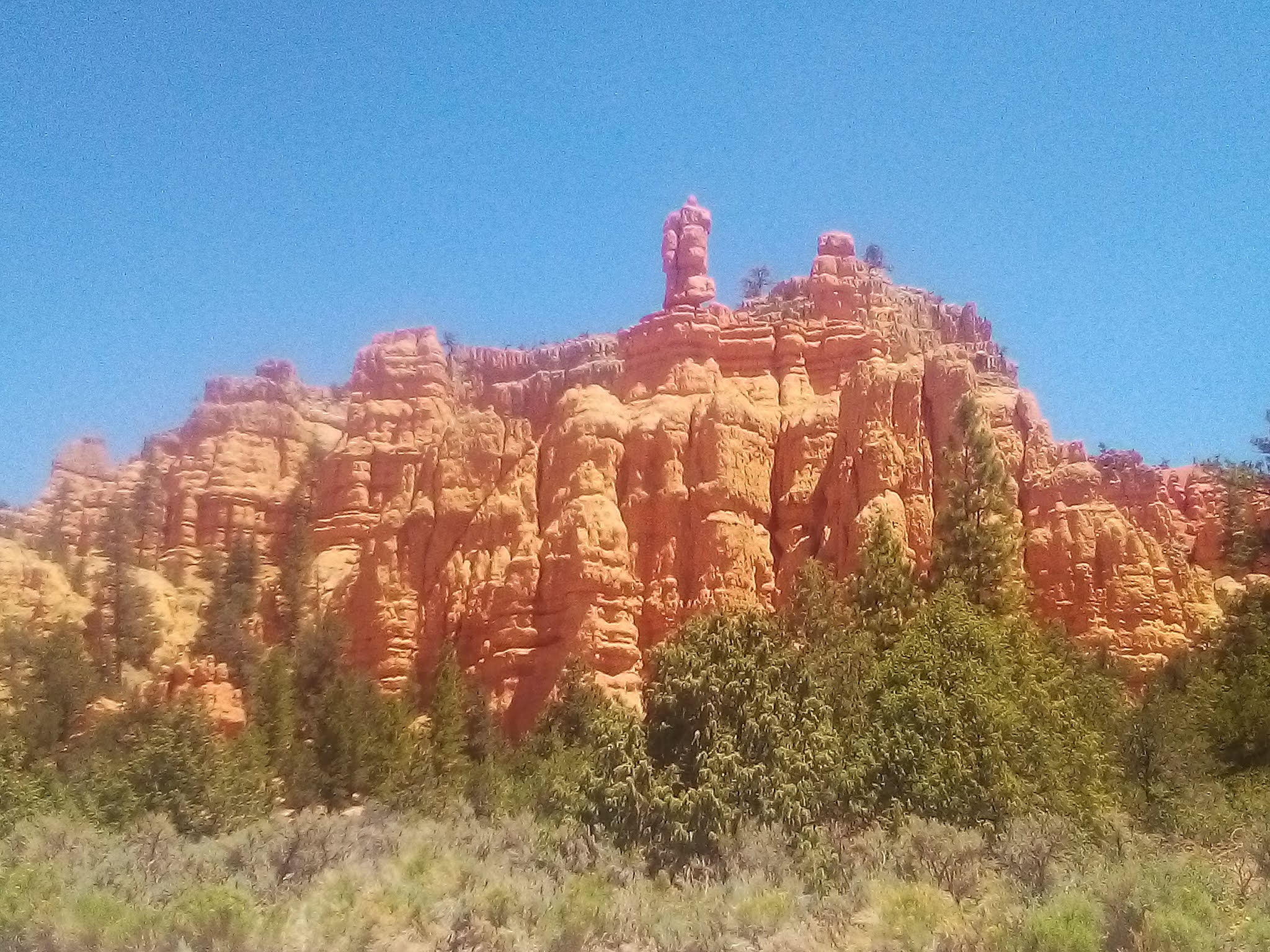
But within a mile or so, all of that dropped off as I drove into the red canyonlands eastward. It was surreal, like I had unwittingly crossed from this world to another. Here, the earth itself was reddish-orange, neither the dark sod of Nebraska nor the pale chalky caliche of Nevada. The fireborn clades of pines make their home in all of these places, and that was especially true here. Not far from here was Red Canyon, a decent-sized tract of Forest Service land designated as part of Dixie National Forest. There was a visitor center and a series of trailheads breaking off from next to the road, all meeting back up at the visitor center. There were interpretive signs by each of these trailheads explaining the history, geography, and wildlife of the place, and I would end up photographing all of it. (I'll post those in the pics post accompanying this one, for those interested.)

But at first, I drove right by it on my way to Bryce Canyon. When I got there, it felt like Disney World. You can't just drive right in; apparently there's too many visitors for that, the roads would be clogged. So they have a place to park outside of Bryce Canyon, where you then pay your $38 and hop onboard a bus that takes you there, and the buses leave so often and every single hotel in the parking area has its own bus stop, like it's an urban downtown.
I accept the need to keep visitor impacts on the environment minimal, and therefore the bus system is a good idea. I even accept that some tourists are liable to have disabilities that would make some kind of a nearby hotel necessary. And I
definitely accept that the solution to massive yearly visitor numbers is to find ways to reduce their impact on the local environment instead of putting up gates and only letting the bourgeoisie in.
But I will never, ever, not for the life of me, accept the idea that the citizens of America have to pay their own government by the day for the
privilege of seeing their very own patrimony. I understand that the National Park Service had its funding cut by repeated administrations, and had no other choice. I don't blame them for keeping the lights on and their workers paid. I blame the federal government for not properly funding their operations so we can enjoy our birthright without paying a ransom. And it's a miserly sum, to boot: the National Park Service is expecting to spend
less than $5 billion in fiscal year 2022. Apparently, in 2016, park entry fees only made the National Park Service
about $186 million, a drop in that $5 billion bucket. We spend over $700 billion every year on imperialism; we could cancel like one fighter jet and make the parks free for decades. I don't see why we can't; it'd improve the lives of millions of Americans in a truly tangible way.
In any case, after finding out the grim reality that our national patrimony is now a glorified theme park, I decided to leave Bryce Canyon for another day, heading back to Red Canyon where I could hike for free. After taking the aforementioned photos at the visitor's center, I knew I didn't have time for a very long hike. So I chose the shortest, but most vertical trail. Not even a mile long, but I would work hard for every foot.
This was, without a doubt, the most scenic part of the day. I took dozens of photos, and every single one of them is a banger, so picking the most representative one to put next to this paragraph is difficult. So I went with the evidence that I did actually climb this beast. If you look down at the road, you can see my trusty battlevan parked at the bottom. But the vista was worth the climb; you can see all across this canyonland from the top.
Though the view was worth it, getting there had been a tad hardcore. So after getting back to the battlevan, I decided to drive to another point I'd noted on the way in: a canyon on the side of the road. It wasn't marked, other than a sign about Butch Cassidy and the Sundance Kid (see the pic thread for that). There wasn't even really a trail; the bottom of the narrow canyon was the trail. It climbed into the hills very gradually; I could've brought a wheelchair through it without too much difficulty.

Though much less challenging a hike, its gentleness let me focus on the nature surrounding me. I found some plants I'd never seen before, like this here flower. I didn't study botany in college, and I never think to bring my plant identification books with me on a hike, so I still don't know what the stuff I found is called. But it was pretty, and the landscapes I shot in that canyon compete with each other in aesthetic allure. Going through these photos again, I think I'm going to draw at least one of these this winter. The pic thread will have them all, but since most of the rest of my trip was spent white-knuckled praying for better gas mileage, I'll also illustrate most of the rest of this post with them.

Anyhow, those prayers and that travel. There aren't a whole lot of direct routes between the Bryce Canyon area and Wells, NV. The closest thing to that is to cross the mountains from Highway 89 to I-15 headed north, then to get off for State Highway 160, then take that four miles north to where it connects up to State Highway 21, which goes diagonally northwest towards the Nevada border near Ely. The exit situation was a bit needlessly complex when I got there; I don't see why they couldn't have put in an exit to go directly from the interstate to State Highway 21. But they didn't.
But that wasn't even the hardest part of the journey home. There were several ways through the mountains between Highway 89 and I-15. The shortest, most direct route is State Highway 20, and upon reflection I might've saved my nerves from fraying by going that way. But I did not. My gas indicator was full enough that I figured I could take the roughly equidistant State Highway 143 from Panguitch to Parowan, what the local signs helpfully indicated to be the scenic route.

Scenic it was, but I was too busy worrying about my gas to take too many pictures. Red rock gave way to grey again, but summiting that range took a bigger chunk out of my battlevan's gas tank than I had expected. By the time I had crested the peaks, I was desperate to coast as much as possible. I passed a dump truck going five whole miles an hour down that range, for reasons sensible to dump trucks but not to gas-bereft battlevans. Some Toyota Corolla pulled out in front of me, and then a mile later realized their mistake and let me pass, because they were tired of being tailgated for hitting the brakes too often. I didn't worry too hard about speed limits so long as mine was the only car in sight, letting gravity tug me faster and faster, braking only when I felt too unsafe to ignore it any longer. It worked; I rolled into Parowan with my gas light singing at me but I rolled into Parowan all the same. I gassed up and got on I-15.
That said, there was a little bit of a lake near the summit, and a little bit of a river descending it. It was hard to see from the road, but I was driving with the windows open and I heard the roaring of great water, saw a canyon below me to the left, and pulled over just to be sure. It was worth the momentary stop, and I got a few pictures.
After that, the trip was a lot less eventful. Because I-80 in western Utah is a desolate waste, I was expecting much the same of State Highway 21. But there is no ancient salt lakebed out that way, and instead there are some light rolling hills and forests. It's also fairly directly on the way to where I was going, something that's rarely true of anything in the state of Utah. The only real town along the way is Milford, a quiet little place to gas up and get back on the road.
At the Nevada border, the Highland Ridge looms in the background, peaks named for explorers and President-liberators. Just this side of the border, a little town called Baker has a gas station and a fairly artsy-looking coffee shop, and is surrounded by beautiful views. The next time I pass this way, probably on my way to either Denver or a goldfield, I'll be sure to stop in.
Driving through the Highland Ridge, one temporarily forgets they live in a desert. At a high enough altitude, Nevada is just as efflorescent as any other state. Forests and all kinds of colorful flowering plants line the view as far as the view extends. It's all nestled in Great Basin National Park, a place I haven't yet visited but one I'm eager to investigate next year. I suspect I'll get some good photos out of it when I do.
After getting through the inhabited canyon maze called Ely, and gassing up at the Shoshoni-owned Chevron (cheapest gas in town, and it helps the Shoshoni nation), I headed north. There is only one town of any real size between Ely and Wells, and all I can ever remember about it is that the Mormon church there has an excellent gardener. Every time I drive by it, there's a tiny little Garden of Eden among the desert wastes.
Past that town, there's a rest area, where I got out and took some pictures, like the one next to this paragraph. This is barely outside my stomping grounds, though; this is about where I start getting reception for my local radio stations again.
And then I got to Wells, spent the last of my quarters filling the tank one last time, and got home to tend to my crops. After the better part of a week, they were rather thirsty, but everything save my salad greens had pulled through just fine. And even the salad greens sent up new shoots once the roots tasted water again.
All in all, it was quite the adventure, and reliving it while typing it up, it's a series of lovely memories. Knowing that I made it back just fine, knowing that nothing truly bad happened, the memories are a lot nicer than the lived reality.

But I did see a lot. Despite not getting into Bryce Canyon, just travelling there was a gorgeous day trip. The stuff I saw just outside it, in Red Canyon, was every bit as aesthetically compelling as the videos of Bryce Canyon that I saw. I'm as convinced as ever that the real, unsung national park system is our interstates and our highways, where anyone can see this continent at its prettiest for the price of a tank of gas. Hell, you can apparently go gold panning there too. And the Forest Service and Bureau of Land Management offer everything the National Park Service offers, but for free. Despite everything, it really wasn't just a trip - it was a vacation, and one I'd happily repeat. I will be back - to Red Canyon, to State Highway 12, to Great Basin National Park - and next time, I'll stop more often and take more pictures, and eventually draw those pictures.
Thanks for reading this far. Of course, I don't have adventures like this most of the time - I'm usually down on the homestead, building the collective. But to read more accounts like this, to see some of the art I make in high resolution, and to help fund the collective's growth, I can always use your support for
my Patreon. The picture thread will drop on Monday, so be sure to come back for that.


No comments:
Post a Comment
Spam and arrogant posts get deleted. Keep it comradely, keep it useful. Comments on week-old posts must be approved.